
Archaeological Potential
Excerpted from a report submitted to the Historic American Building Survey (HABS) by Rebecca H. Sell and "The Lazaretto: The Cultural Significance and Preservation Plan in the Spirit of the Burra Charter" by Rebecca H. Sell, A Thesis in Historic Preservation, Master of Science in Historic Preservation, University of Pennsylvania, 2005.
V. ARCHAEOLOGICAL POTENTIAL
The importance of the Lazaretto site is substantiated not only by what remains above ground, but what could potentially be below grade. Most changes that have taken place on the property have occurred on the earth's surface sealing off the wealth of information that is believed to lie in the ground. There have already been important findings from archaeological investigations on adjacent sites, as described below. However, there are no known archaeological investigations that have taken place on the site and no new construction deeply penetrated the ground. The Lazaretto Property thus has great potential to yield archaeological evidence that could contribute to its scientific and historic value.
A. Native American Evidence
In October of 1990, MAAR Associates, Inc., in association with Frens and Frens, submitted a "Historical Documentation and Archaeological Investigations Conducted at Governor Printz Park, Essington, Delaware County, Pennsylvania" to the American Swedish Historical Museum and the Pennsylvania Historical and Museum Commission. This document contains histories of past archaeological investigations and the information yielded as well as the results of their own project. Although their studies were conducted at Governor Printz State Park, their findings make reference to the Lazaretto. Close proximity (less than 500 feet to the west) to the Park indicates the potential for similar evidence to be located on Lazaretto Property, as the banks of the Delaware River had a high concentration of Native American inhabitance.
Early archaeological excavations at Governor Printz State Park uncovered significant amounts of Native American artifacts. Native American objects were recovered in each of the three previous archaeological investigations. In 1990 alone, a total of 20,989 historic artifacts, 569 prehistoric artifacts, and 29 protohistoric artifacts were recovered. There is a high probability that similar results would be gained from an archaeological investigation or survey of the Lazaretto Property (see figure 93).
B. Swedish Settlement Evidence
While most of the artifacts and architectural ruins of the Swedish Settlement were uncovered at the Governor Printz State Park, there is historical documentation indicating that the settlement extended eastward including the Lazaretto site. Histories of Delaware County, such as George Smith's History of Delaware County, Pennsylvania published in 1862, Henry G. Ashmead's history of the same name published in 1884, and J. Thomas Scharf and Thompson Westcott's History of Philadelphia, also published in 1884, indicate that the center of the Swedish Settlement was indeed concentrated on what is now two properties, the Governor Printz State Park and Corinthian Yacht Club property. However, there is ambiguity about some buildings' exact locations, the burial ground, and the boundaries of the village.
According to Ashmead, in the mid-seventeenth century, Tinicum Island was about a mile-and-a-half wide and surrounded by waterways. On the southwest point of the exposed land, the Swedes built "a little Lutheran Church made of logs, and the remains of the large block-house, which served them in place of a fortress, and the ruins of some log huts." Near the church was a burial ground located near the Tinicum Hotel, operated by Jacob Pepper. The 1870 diagram indicates the location of Pepper's House, which he operated as Tinicum Hotel, as being just west of the six-acre Government Property (see figure 21). This is an indication that the burial ground is somewhere on or near the six acres adjoining the modern Lazaretto Property, the present location of the Lagoon. However, Ashmead does go on to explain that the burial ground has been washed away and therefore is somewhere in the Delaware River if it survives at all.
Dr. George Smith also gives a description of the church and burial ground's location: "The site of the burying place, and doubtless that of the church also was close to the margin of the river, and is now occupied by a part of its bed between the Lazaretto and Tinicum Hotel, but nearer to the latter." This suggests the burial ground is possibly on the six-acre property adjoining the Lazaretto.
Scharf and Thompson give their own description of the church and graveyard locations. "On the Delaware side of Tinnecum were situated Printz's Hall and the first Swedish Church and churchyard on the Delaware, consecrated in 1646. This spot is now occupied by the Philadelphia Quarantine station and the Lazaretto Hospital, the site of the ancient fort and grounds belonging to it being adjacent to what is now the Tinnecum Hotel." Their account would make the location of these resources closer yet to the Lazaretto Property and somewhere on the six-acre property.
Earlier archaeological investigations of Governor Printz State Park, performed by Donald A. Cadzow in 1937, revealed information suggesting that of the Swedish village extending as far as La Grange Street, east of the Lazaretto. In a letter dated October 15, 1937, Cadzow explains his findings to Mr. A. E. Demaray, Associate Director of the National Park Service:
"We believe the Swedish settlement on Tinicum Island extended up the Delaware River from the property of the Corinthian Yacht Club, across that now owned by the Commonwealth of Pennsylvania, under Taylor Avenue and on to the property of Charles Walber, then eastward across the property owned by the US Government, and on to the old Lazaretto Property sold by the city of Philadelphia to Frank and Anna Mills, on January 6, 1937. According to George Smith, History of Delaware County, H.N. Ashmead, Philadelphia, 1862, the settlement occupied about 25% of Tinicum Island. If this is true, the ruins of the old village would extend well eastward across LaGrange Street and into the modern town of Essington."
Maps and illustrations of the Lazaretto and Governor Printz State Park also make reference to the Swedish Settlement exceeding the boundaries of the Park. A detail on a map by Bowen dating to 1862 illustrates the locations of early settlements and clearly marks the location of the "Printz Hall Church" (see figure 11). When compared to similar maps of Tinicum Island, the church is located in the same vicinity as the Lazaretto Property (see figures 2 and 26). A sketch plan, speculatively dated to the late 1930s, entitled "Plan of Property Adjacent to Printz-Lindbergh Park," has a graphic overlay that extends the "Site of the Swedish Village" over the six-acre "United States Government" tract and well in the "Old Lazaretto" property (see figure 93).
C. Foundations of Demolished Structures
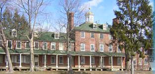
As expressed in previous sections of this thesis, the architectural remains of the Lazaretto Property are only part of what was once a larger complex, with more than twelve buildings and a more than twelve buildings and two wharves stretching over sixteen acres of land along the Delaware River. Although, many of these structures have been demolished, there is a potential that their foundations may still remain buried below grade. The exact locations of some structures that have been mentioned in historical descriptions of the Lazaretto are unknown. However, most of the structural resources have been well-documented in description and historical maps retaining their precise locations (see figure 9). The former locations of significant structures that played an important role in the story of quarantine, like the Hospital Building, the Quarantine Master's House, Watch House, Ice House, Barrack, and Old Custom House, can all be located and may have foundations or other associated archaeological resources embedded in the ground.
There are other resources that might be uncovered by archaeological investigation. The landscape of the Lazaretto throughout the nineteenth century was manicured and kept by a gardener. Many fresh fruits were grown in an orchard and vegetables were collected from gardens. The Physician's House and Quarantine Master's House had private gardens. The Orchard Club also maintained the landscape and had extensive grape arbors lining the yard (see figures 33 and 34). Poking through the mown grass just south of the Main Building are iron railway tracks that were used during the Lazaretto's use as a seaplane base. These tracks lead directly into the corrugated sheds, water, and other locations along the front yard. Again, only portions are visible, but there is a potential to uncover what is left of the seaplane tracks.
D. Onsite Burials
Since the quarantine station at the Lazaretto was mandated to bury those who died at the facility and other victims of contagious disease on the grounds, the site has significant archaeological potential to yield those graves and human remains. The graves were largely unmarked. Those that were have since lost their headstones. However, there are articles and citations in newspapers discussing the burials at the Lazaretto.
An excerpt from the Upland Union issued July 8, 1846 writes,
"During June, vessels at Lazaretto examined 123, of which 1/3 were from foreign ports and others coastwise. A majority of latter are not obliged by Quarantine regulations to stop at the Lazaretto. Ten persons were placed in the hospital and three have been buried at this place during the month."
Another excerpt from the Delaware County Republican issued August 29, 1851 writes,
"Edward Miller, aged 23 years, died in the Lazaretto Hospital, on Sunday last, of Southern fever. He had been left at the station a week previous by the big Emily Weaver, from Mobile. — His father resides at Pottsville, Pa. Every attention was paid to the unfortunate young man at the Lazaretto, and his remains were entered in the burial place there."
A detailed account of the Lazaretto burial ground is described in an article, "The Forgotten Dead: Neglected Graves at the Old Quarantine Station at Essington," in the Chester Times on December 5, 1899. This article was written during the period when the Athletic Club of Philadelphia was using the Lazaretto as a summer home called the Orchard Club.
"In the grounds of that place is a space of ground about 100 feet square, where are buried threescore of bodies which have long ago been forgotten, and there is no one who can recall their names. The graves are unmarked. There are a few boards standing denoting the place of the graves, but time has obliterated the names of any which were ever there. . . It is in the far northwestern corner of these grounds, far away from the river, and shaded by a little scrub tree, that the bodies rest. When the athletic club took the grounds it laid out a baseball diamond, and the right field lies close to the graves. While the names of the persons who died are not known, yet it is remembered by 'Dave' Brown that in one of the mounds rests the body of a former quarantine physician. 'Dave' is an old gray-haired colored man who has been connected with the Health Bureau for more than sixty years. The physician was honored with a more pretentious grave than the others. His resting place was built up of brick and the ruins are still in evidence. The other dead, as best 'Dave' can remember, range from captains of large ships to poor and ignorant immigrants. A majority of them died of typhus fever, know to sailormen as ship fever."
The article also explained that the Bureau of City Property petitioned City Council for $1000 to remove the bodies to Arlington Cemetery near Angorra, Pennsylvania to a "proper graveyard" for a "decent burial."
By April 13,1900, "under the supervision of Colonel S. Lewis Good, Chief of the Philadelphia Board of Health office, the several hundred bodies interred in the old burial grounds at the Lazaretto, in Essington, [were] being exhumed and placed in small pine boxes for removal to the Arlington Cemetery, Upper Darby." According to photographs of the Orchard Club's baseball field, the gravesite would be somewhere northwest of the Main Building near the site of the now demolished Hospital building (see figures 9 and 32). The author visited Arlington Cemetery in what is today Drexel Hill. The Records Manager could not find a record of where the remains were buried and indicated that often anonymous or unknown burials were also left unmarked in their cemetery. It should be noted that the 1900 exhumation does not detail the methods used, size or number of burial locations, nor level of completeness.

