
Site Description
Excerpted from a report submitted to the Historic American Building Survey (HABS) by Rebecca H. Sell and "The Lazaretto: The Cultural Significance and Preservation Plan in the Spirit of the Burra Charter" by Rebecca H. Sell, A Thesis in Historic Preservation, Master of Science in Historic Preservation, University of Pennsylvania, 2005.
II. SITE DESCRIPTION
The site of the Lazaretto Quarantine Station is situated just south of the Philadelphia International Airport, ten miles southwest of Philadelphia, along the Delaware River, in the industrial town of Essington, Pennsylvania, at Wanamaker Avenue (Route 420) and Second Street (see figures 2-5 and 8). The following building names and terminologies will be used throughout; they are shown own figures 6 through 9:
Lazaretto Quarantine Station:
- Lazaretto Property (approximately 10 acres)
- Government Property (approximately 6 acres)
- Riverside Yacht Club (approximately 1.32 acres)
- Main Building
- Bargemen's House
- Kitchen House
- Corrugated Shed 1
- Corrugated Shed 2
- Physician's House
- Stable
- Gate
- Watch House
- Quarantine Master's House
- Ice House
- Boat House
- Quarantine Landing
- Hospital
- Government Store House or Barrack
- Wharf
- Old Custom House
- Burial Ground
- Laundry House
- Passenger's House
- Power-house
- Gardens
The Lazaretto Quarantine Station is defined as the ten-acre Lazaretto Property, 1.32-acre Riverside Yacht Club Property, and the six-acre Government Property combined — essentially, the original overall site. Historically the structures on all properties worked in conjunction as the Lazaretto Quarantine Station. The Lazaretto Property, also referred to as the "Quarantine Station Proper," is the ten-acre parcel bound south by the Delaware River, east by residential properties, north by Second Street, and west by the Riverside Yacht Club and the six-acre Government Property, which is today the Lagoon, a restaurant, motel, and nightclub. This property was put up for sale in June of 2000 and quickly became the focus of preservation interest. In July of 2005, Tinicum Township purchased the Lazaretto Property for 3.1 million dollars. The Riverside Yacht Club Property was originally part of the Lazaretto Property, making it a total of 11.32 acres. Although, 1.32 acres was leased to the Riverside Yacht Club in 1937 and then eventually sold to them in 1939. Today it is bound south by the Delaware River, east by the Lazaretto Property, north by the same, and west by the Lagoon. The Government Property was historically a six-acre parcel bound east by the Lazaretto Property, north by Second Street, west by a hotel, and south by the Delaware River. The United States Government sold the property in 1951, after over 150 years of ownership, and it has changed title only twice more since that time. Through these transactions, it has been combined with the westerly lot, forming a 8.78-acre parcel, and is now bound west by the Governor Printz State Park. Today, the Government Property is occupied by the Lagoon and large parking lot (see figure 9).
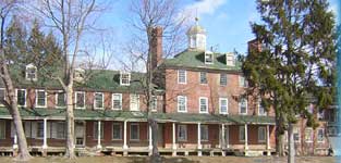
On the Lazaretto Property there are five remaining historic structures: Main Building, Bargemen's House, Kitchen House, Corrugated Shed 1, and Corrugated Shed 2 (see figure 9). The Main Building, also referred to as the Administration Building or Hospital, is the central and largest building on the Lazaretto Property (see figures 33-41). The Bargemen's House, a smaller structure, is located southeast of the Main Building (see figures 65-67). The Kitchen House, a small brick structure just north of the Main Building, is now used as a garage (see figures 61-64). Corrugated Sheds 1 and 2 are situated on the front lawn, south of the Main Building (see figures 68-71). The Physician's House, Stable, and Gate are located to the west of the Main Building on the Riverside Yacht Club Property, but were historically part of the Lazaretto Property (see figures 72-79). Other major structures on the Lazaretto Property pertinent to the Lazaretto Quarantine Station, but since demolished, were the Watch House, which mirrored the Bargeman's House along the waterfront; Quarantine Master's House, which once flanked the Main Building on the east and mirrored the Physician's House; Ice House, which stood northeast of the Main Building; Boat House that once stood east of the Bargemen's House; Quarantine Landing that once extended out into the water from the land; and Hospital, also referred to as "Smallpox Hospital," once located at the northwest end of the Lazaretto Property (see figures 20 and 21). Current research suggests there was also a Burial Ground located near the Hospital in the northwest ground of the same Property. On the adjoining Government Property there were three major structures used in the Lazaretto Quarantine Station operation: the Government Store House or Barrack, Wharf, and Old Custom House (see figures 9, 20, and 21). These buildings have since been demolished.
Currently, the Main Building and remaining outbuildings are in stable condition, retaining a nearly original viewshed uninterrupted by industrial development (see figure 88). The northern half of the Lazaretto Property is largely vacant (see figures 85 and 86). A dry dock now occupies the property. Disabled boats and boat parts are strewn along the north and south lawns and a shop for boat maintenance and repair occupies the Main Building's first floor east wing (see figure 87). A seaplane operation ran out of the first floor of the west wing, using the corrugated sheds for storage, but vacated when the property sold in July of 2005. The center hall of the Main building and upper floors of the east and west wings have been left vacant.
Land use surrounding the study area is mixed and contains residential, commercial, industrial, and recreational parcels. Residential properties dominate the area and consist of single-family detached units, twin houses, and apartments. The commercial uses serve the neighborhood and are not laid in any pattern or clustered business district. The largest of these nearby parcels is the Lagoon, which functions as a hotel, restaurant, and nightclub, while the remainder of the lot is paved for vehicular parking. Along the Delaware riverfront there are sites of industrial development that operate in the production, movement, and storage of goods. East of the Lazaretto Property are residential properties. The Riverside Yacht Club to the west also provides boat storage, but functions as a private recreational facility. Other recreational uses in the area are Governor Printz State Park, a public space, and further west the Corinthian Yacht Club, another private organization (see figures 6, 7, and 10).
The natural environment of Tinicum Township has changed dramatically over the years. This area, a former island historically known as Tinicum Island, was covered with and surrounded by swamps, tidal mud flats, and many wandering streams that made it nearly inaccessible by land. These wetlands provided an excellent agricultural resource. However, when farming and grazing were abandoned in the late nineteenth century, the process of infilling and developing commenced. The eastern end that was defined by Bow Creek has been completely infilled, and the former bed of the creek lies beneath the runways of the Philadelphia International Airport. Other creeks and runs like Hulk Run, River Creek, Reed Spurta, Freeman's Creek, and Smith's Cinders Run have also disappeared. The northern edge of the island has been altered due to Interstate 95 construction. Natural erosion, sea wall construction, dredging, and pier development along the southern side of the island has changed the historic appearance of the waterfront. Today, there is the only one identifiable stream, Long Hook Creek, that remains within the bounds of Tinicum Island.
The landscape of the Lazaretto Property today consists largely of mowed grass. From the south of the Main Building and down to the waterfront, grass has grown over tracks that were once used to move seaplanes in the twentieth century. Small sections of the tracks are still visible. Overgrowth of weeds and bushes near the water's edge have taken over many of the twisted metal structures, formally used for seaplane transportation, and have created a small wetland (see figure 90). Several large trees stand a few yards south of the Main Building. An old, large tree stands by the banks of the river and can be identified in historical photographs (see figures 89, 109, 110). The viewshed from the Lazaretto Property looking south is an uninterrupted view of a river environment. The lushness of Little Tinicum Island in the Delaware, visible from the complex, and banks of New Jersey perhaps suggest the original scene that may have been seen from the Lazaretto in the early nineteenth century (see figure 88).