
Resources
Excerpted from a report submitted to the Historic American Building Survey (HABS) by Rebecca H. Sell and "The Lazaretto: The Cultural Significance and Preservation Plan in the Spirit of the Burra Charter" by Rebecca H. Sell, A Thesis in Historic Preservation, Master of Science in Historic Preservation, University of Pennsylvania, 2005.
III. RESOURCES
The original Lazaretto Quarantine Station consisted of a complex of resources including the Main Building, Bargemen's House, Kitchen House, Physician's House, Stable, Gate, Boat House, Watch House, Quarantine Master's House, Hospital, Ice House, Laundry House, Power-house, Passenger's House, Quarantine Landing, Gardens, Burial Ground, Government Store House or Barrack, Wharf, and Old Custom House. However, the only remaining resources are the Main Building, Kitchen House, Bargeman's House, Physician's House, Stable, and Gate. Although the dates of construction and/or demolition of some resources are unknown, tracing atlases, renderings, and written documentation speculation can be made about the development of the site.
- Remaining Architectural Resources
- Main Building
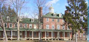
The Main Building faces south toward the Delaware River and is the largest building on the Lazaretto Property (see figures 33-41). Built circa 1799, it is a symmetrical structure with Flemish-bond brickwork, constructed in the late-Georgian style with a slightly projecting central pavilion and flanking wings. The building is reminiscent of the Pennsylvania Hospital on Eighth and Pine Streets in Philadelphia, Pennsylvania — the oldest hospital in the nation, the Pennsylvania Hospital is considered one of the finest examples of Georgian medical architecture. A water table, string coursing, and sash windows articulate the Main Building's façade, while dormer windows protrude from the roofs. Paneled shutters, like those remaining on the first story of the west wing, once covered all of the first story windows. All of the windows without shutters still retain the original iron shutter dogs that once held them open (see figure 42). Louvered shutters, perhaps those located in the west wing basement, would have likely been on successive story windows. Photographs from the 1930s show the louvered shutters still in place (see figures 35 and 36). Today, a colonnaded porch lines the first story of the center pavilion and west wing, but used to continue across the east wing as well (see figure 43). The original cupola surmounts the roof of the center building (see figure 44). There are twenty-eight rooms in all, and a fireplace in almost every room (see figures 50-52).
The center pavilion is a handsome, solid, five-bay structure, fifty feet square (see figure 38). Unlike its two-and-one-half-story, adjoining wings, the center building is three-and-one-half stories. The first story has a door with fanlight flanked by two, two over two sash windows symmetrically and evenly spaced across the façade. Five, twelve over twelve, sash windows on the second story align with those on the first story. A string course separates the second story from the third story which also has the same pattern of sash windows. However, the third story windows are squat containing eight over twelve lights as they abut the hipped roof covered with green asphalt shingles (see figures 40 and 41). Historic American Building Survey (HABS) photographs, taken in 1936, show a standing seam metal roof (see figures 33-36). Two, eight over eight light, dormer windows project from the half story while two large brick chimneys rise above from the third story (see figure 46). On top of the hipped roof there is an octagonal cupola, opened by eight, ornate, twenty-one light, arched windows, two of which are missing today (see figure 43). An iron ball and weathervane are intact atop the cupola (see figure 45).
The rear of the Main Building and its wings echoes the design of the façade (see Figures 38 and 39). However, the center pavilion protrudes from the rear dramatically, a single dormer projects from the east and west sides of the center pavilion roof, and three, sash windows are located on the north ends of the east and west-facing walls. Also, the center bays of center pavilion and adjoining wings are set low in order to light the interior stairwells and there is no string coursing. Additional entrances have been opened in the back of the east wing for modern restroom facilities and boat-repair functions. An ornate, iron, lighting fixture remains bracketed to the north façade (see figure 82).
Wings extending east and west retain many of the same characteristics as the adjoining center pavilion (see figures 33-41). They are nine-bay, brick structures, sixty-five feet by twenty-six feet wide and two-and-one-half stories high. The first story doorway at the center of each wing has a fanlight and is flanked on the west by four, twelve over twelve light, sash windows with shutters and on the east by four of the same style windows without shutters. The second story of each wing has nine windows of the same type symmetrically in line with those of the first story. The half story's pitched roof includes three evenly spaced dormer windows with eight by eight lights.
Although the adjoining wings have been renovated into apartments, the central pavilion retains much of its original interior configuration, finishes, and architectural details (see figures 47-59). It contains twelve rooms, each twenty by twenty-four feet, with ten-foot ceilings, and a fireplace in each room. There is a central hall plan, two rooms deep, with a center stairwell (see figure 60). The National Register Nomination Form, approved in March 1972, goes into great detail about the interior; a description consistent with today's conditions:
"The stairway with plain unfluted pilasters to dado height at the first floor landing, is to the left of the hall. The railing, with rampings and easings between the first and second floors, and the thin square balusters with channel mouldings on all four sides are very graceful.
The left front room on the first floor was probably the office and receiving room. The very handsome Welford-type mantel, perhaps by Zane and Chapman, with gouge carving and composite columns, has composition work baskets, flowers, garlands, and urns.
The right front room was probably the dining room and opens into the rear room by means of a folding paneled partition.
Each room on the three floors of the center section has a fireplace except the first floor left rear room. [It is speculated, by historic architect John Milner, that this fireplace has been sealed over]. The built-in cupboards and out-side door in this room suggest that this was a pantry and preparing room. Several feet from this outside doorway is an old brick structure, now a garage whose window retains its original wooden shutters. The scar of a brick passageway around the exterior of the 'pantry' doorway suggests that at one time this outbuilding was the kitchen, and a 1911 magazine clipping in the Anna Broomall Notebooks at the Delaware County Historical Society show that the end chimney was along the east wall where the garage doors have now been out.
The second and third floor rooms and the first floor right rear room are all similar in plan with a built-in cupboard to either the right or left of the fireplace. Each mantel is simply but well moulded, and the fireplace surrounds are plain except in the second floor right front room and the first floor back right room where the mantel shelves are supported by unfluted pilasters. The latter retains its original iron fireback.
The dados, innerside of the doors, and mantels have been repainted and the original color combinations were blue and yellow, green and beige and pink and yellow. The outerside of the doors and some of the mantels were stained to look either walnut or mahogany."
On October 27, 2004, staff and interns from the Northeast Region of the National Park Service, historians, and architects gathered at the Lazaretto to document the Main Building with drawings and photographs. During this data collection, one of the key participants, historical architect John D. Milner, remarked that little had changed in the center hall, which still retains most of its original flooring, box locks, doorway architraves, shelving built into the walls, and fireplace detail with a hierarchy of design from the first story to the third (see figures 47-54). Milner also speculated that the wall finishes may be original, as whitewashed walls were standard in early medical facilities. Notable as well is the half story attic space, which still contains a platform for a large water cistern and stairway to the cupola (see figures 55 and 56). A photograph from a 1992 newspaper article shows lighting fixtures hanging in each landing of the stairwell that have since been removed (see figures 53 and 54).
The wings of the Main Building were used as the hospital and quarters to house the sick and convalescing and referred to as "the Lazaretto." The west wing was also used as servants' quarters. Part of the central pavilion was the Steward's Apartment while the remainder was used for administration and social purposes for the Board of Health, which can be gathered by reviewing inventories of the building from the early nineteenth century detailing a Committee Room, Dining Room, Gardener's Room, and Laundry Room. A description from a local newspaper, the Delaware County American, from 1862 described the property:
"Externally, even yet, the grounds retain a portion of their attractiveness, whilst within, in hall, corridor, chamber, and everywhere, the spirits of order, and neatness appear to hold undisputed sway."
According to an 1895 account, the Main Building had enough cots to accommodate 500 persons and enough space for 200 people on the unoccupied land. There were also 100 wall tents and floors available. The water supply was clean and pure. It was pumped out from a 300-foot-deep artesian well by steam engine into a 3,000 gallon cistern in the Main Building, thence distributed throughout the building. Everything leaving the Lazaretto was thoroughly disinfected, including all dejections and discharges from patients. On the first floor of east wing there was an apparatus for disinfecting the mail from patients to the outside. Heated by alcohol and held at a dry heat temperature of between 300 and 400 degrees, all outgoing mail was treated and marked "sterilized" on the envelope before being forwarded to the local post office.
- Bargemen's House
- Kitchen House
- Physician's House
- Stable
- Gate
- Demolished Resources
- Boat House
- Watch House
- Quarantine Master's House
- Hospital or Smallpox Hospital
- Ice House
- Laundry House
- Power-house
- Passenger's House
- Quarantine Landing
- Gardens
- Burial Grounds
- Government Store House or Barrack
- Wharf
- Custom House
Another remnant outbuilding on the Lazaretto Property is the Bargemen's House located southeast of the Main Building facing the Delaware River (see figures 65-67). It is a fifteen-by-fifteen-foot, cube, brick structure, covered in stucco, with a one-story elevation. According to historical drawings it abutted the banks of the river (see figure 27 and 28). However, today it is separated from the banks by later land fill. There is one entrance on the north elevation of the structure. The façade, now covered in ivy, has a large, arched inset window facing the river (see figure 67).
The Bargemen's House date of construction is unknown as it was not mentioned in the Board of Health Minutes. The Bargemen's House was paired with the Watch House, now demolished, that was placed southwest of the Main Building creating symmetry in plan. When vessels were sighted by a lookout in the Watch House, bargemen facilitated the Lazaretto Physician and Quarantine Master by boarding a barge or steam tug (applied for in 1868) traveling out to the location of the inbound vessel in the River, and bringing them back to land.
To the north of the Main Building, on the Lazaretto Property, is a small, brick garage that is speculated by local historians to have been used as an outdoor kitchen (see figures 61-64). The date of construction is not known. Although historically kitchens were located in the wings of the Main Building, heavier cooking may have taken place in this structure. Many changes have been made to the Kitchen exterior. On the north wall there is evidence of a door opening, since blocked off with brick (see figure 62). A small modern window was added to the left of the door outline. The west wall has been removed and wooden garage doors were installed (see figure 61). The south wall appears to have maintained a perhaps original window opening with large wooden shutters and original arm hinges (see figure 63). It appears as though no change has been made to the east elevation and a door opening exists in the center (see figure 64). The roof is steeply pitched and covered with the same green shingles as the Main Building.
Located on the Riverside Yacht Club Property, once part of the Lazaretto Property, the Physician's House was commissioned and constructed with the Main Building circa 1799. It is a two-and-one-half story, single forty-eight-by-twenty-four-foot block, five-bay, common bond brick structure that faces the waterfront (see figures 72-74). Its exterior design coincides with the Main Building's late-Georgian architectural style. A sketch drawing, by Frank H. Taylor in 1895, simplistically illustrates the façade of the Physician's House as having only two bays, leaving out three additional bays (see figures 29 and 30). However, a watercolor by T.L. Cernea, date unknown, shows the five-bay façade of the Quarantine Master's House, built in conjunction with the Physician's House and mirroring its design (see figures 27 and 28).
The first story, now covered by an enclosed porch, once had a central door opening, and two flanking windows. A low-pitched porch ran across the length of the first story as well. The second story remains the same with five, evenly spaced, ten-by-ten-light, sash windows. Three dormer windows protrude from the hipped roof. There are interior chimneys on either side of the house. The rear of the house, much like the Main Building, also has five bays of sash windows with the central window set lower to light the interior stairwell. The first story has four windows and a later, central door opening covered by a porch with Doric columns and a decorative balustrade. A one-story wing was added to the east side of the main block of the house some time after 1919 and before 1929 (see figures 24 and 111).
According to the Hand Book of the Lower Delaware River of 1895, an annual publication by the Philadelphia Maritime Exchange, the interior of the Physician's house had seven rooms, two attics, and eleven-foot high ceilings. Bath and water closet appliances "of the most approved sanitary plumbing" were provided as well.
Today, there is a modern, one-story, modern addition flanking the west side of the building. Information regarding the addition is limited due to access restrictions. The interior of the original Physician's House has since been modified for recreational club use.
The Stable is located on the Riverside Yacht Club Property, which was once part of the Lazaretto Property. It is a wooden building with large iron arm hinges on the doors. The Hand Book gives a description of the Stable situated one hundred feet northwest of the Main Building, measuring seventy by forty feet. Today, the stable is boarded up and left unused; however, the interior retains a remarkably intact loft, ladder, stalls, and an uncharacteristic, turned balustrade, possibly relocated from another source (see figures 75-81).
Like other remaining structures, the Stable's date of construction is not known. However, its design, materials, and location indicate that it dates to the early nineteenth century. It should be noted that an article in the Upland Union newspaper indicates, "a brick stable belonging to the Lazaretto was discovered on fire by John F. Dyer . . . the building was insured for 500 dollars."
The Gate, which exists north of the Physician's House just west of the Stable also on the Riverside Yacht Club Property, runs east and west and remains fully intact (see figures 83 and 84). Although its date of construction is unknown, there is a gate illustrated at this location in a diagram dating to 1870 (see figure 20). At one time the Lazaretto Property was entirely enclosed by a whitewashed board fence, according to newspaper articles from the 1870s.
Historic sketches, drawings, maps, diagrams, and descriptions of the Lazaretto site indicate the existence of additional resources since demolished (see figures 15, 16, and 18 to 25). The historical documentation of these resources indicate that they were significant to the site and their historical development must be addressed. It should be noted that there were other resources that were erected and demolished at various times throughout the property's history, but due to lack of sufficient documentation they will not be addressed.
The earliest illustration of the Lazaretto is a diagram, produced in 1870, called "Diagram No. 1 of the Lazaretto Station" reporting the positioning of the brig "Home" in the Delaware River. This ship from Jamaica was believed to be responsible for a yellow fever outbreak in June of that year, that killed at least ten people including the Quarantine Master, Lazaretto Physician, Steward's wife, and a nurse (see figures 20 and 21). This drawing illustrates the original 11.32-acre complex of the Lazaretto Property and the additional six acres to the west that belonged to the United States Government, but was used in conjunction with the station. On the Lazaretto Property, the diagram shows the Main Building, labeled "Hospital," Lazaretto Physician's House, Stable, Gate, Kitchen, and Bargemen's House, which still exist today. In addition there was a Watch House, a Quarantine Landing extending southward into the river, a Boat House on the southeast corner of the plot, a Quarantine Master's House on the southeast mirroring the Lazaretto Physician's House, an Ice House north of the Main Building, and a Hospital, labeled "Small Pox Hospital," located northwest of the Main Building, all of which have since been demolished. On the adjoining six-acre Government Property, a Wharf projected southward from the bank into the river and a structure called the "Government Store House" was north of the Wharf yet south on the property.
Another valuable resource that documented resources and their locations is an account from the 1895 Philadelphia Maritime Exchange Hand Book. This report indicates that there was also a Laundry and Wash-house, Store-house, and Power-house located on the Lazaretto Property. However, their positions were undefined. On the Government Property, the Hand Book describes a Barrack, a Pier that projected southward into the river, and a Steam Disinfectant Plant and a Power-house on the wharf. In 1889, historian Henry J. Ashmead also recalled an "old Custom-house building" at the Lazaretto Quarantine Station. None of these structures stand today.
The 1870 diagram shows the Boat House as located on the Lazaretto Property southeast of the Main Building. There is no written documentation of the Boat House represented in the 1895 Philadelphia Maritime Exchange Hand Book accounts. The date of construction and demolition is unknown.
The Watch House was located on the Lazaretto Property, southeast of the Main Building, and once abutted the water's edge. Although it is not clear when it was constructed, it may have been built with the Bargemen's House. The two designs were identical — a fifteen-by-fifteen-foot, cube, brick structure, covered in stucco, with a one-story elevation and a large, arched inset window facing the river. It was used to house a watchman or lookout who rang a bell hanging inside to notify the staff of an inbound vessel. Its date of demolition is also unknown, however it may have been around 1913 when the property was taken over by a seaplane base. A photograph of the Lazaretto Property from 1916 shows the Watch House intact, but a 1929 photograph shows that it had been razed, probably to make way for a seaplane ramp (see figures 109-111).
The 1895 Hand Book depicts the Quarantine Master's House in the same description with the Physician's House (see figures 28 and 30). It was located one hundred and twenty feet southeast of the Main Building on the Lazaretto Property. Built along with the Main Building and Physician's House at the turn of the nineteenth century, the Quarantine Master's House was home to the Quarantine Master, his family, and servants. In 1895 the house was "temporarily occupied by the crew of the boarding tug" (see figure 9). It measured forty-eight feet by twenty-four feet, consistent with the 1870 diagram, and was "two-and-one-half stories high, [had] seven rooms and two attics each, and [had] ceilings 11 feet high." Matching the Physician's House, the Quarantine Masters House was also fitted with "bath and water-closet appliances of the most approved sanitary plumbing." Although its date of demolition is unknown, it was standing in 1895 according to the Hand Book and not in a photograph taken in 1916 (see figures 109 and 110).
Another prominent building on the Lazaretto Property was the Hospital, or Smallpox Hospital, located about three hundred feet northwest of the Main Building (see figure 9). Construction of the Hospital dates to around 1858 or 1859 when the project was proposed to the City Council. This structure boarded and treated passengers and Lazaretto staff afflicted with smallpox, while the wings of the Main Building contained the main hospital operation. In 1870, this structure was also known as the "Dutch House" because it accommodated many German immigrants afflicted with ship fever. (It should be noted that "Dutch" was a common misnomer, dating back to the 15th and 16th centuries, for people of German descent or heritage. ) In 1895, it was described as "72 feet long by 24 feet wide, two stories in height, contains two wards on the first floor, each 22 by 22 feet, ceilings 10 feet high, and these [were] exactly duplicated on the second floor, which also contains a Nurse's room, Dispensary, Bath-room, and Water-closet, all of the best modern plumbing work." On the west side of the Hospital was an adjoining Kitchen, sixteen by twenty-four feet, and a similar building on the east described as a dead-room or Morgue. Although the date of demolition is unknown, a photograph from 1929 shows the Smallpox Hospital situated at the northwest corner of the Lazaretto Property, but is no longer there in the 1946 Sanborn Map.
There is little documentation about the remaining outbuildings on the Lazaretto Property. The 1870 diagram shows an Ice House in the center of the property, north of the Main Building, and east of the Stable. This suggests it was about one hundred feet or more north of the Main Building, as the 1895 Hand Book notes the Stable being the same distance. The Hand Book also describes the Ice House as thirty feet square.
The 1895 Hand Book describes a Laundry House or Wash-house on the Lazaretto Property as thirty by twelve feet. There is no mention of its exact location, date of construction, or date of demolition.
The 1895 Hand Book describes a Power-house on the Lazaretto Property as "substantially built" twelve feet square over an artesian well. Like the Laundry House, there is no information regarding its exact location or dates of construction and demolition.
Constructed shortly after the completion of the Main Building, Physician's House, and Quarantine Master's House, other buildings were erected including a Passenger's House. According to Scarf and Westcott "a temporary lodging-house for emigrants who were not sick" was one of these structures. An inventory of the Lazaretto Quarantine Station taken on June 20, 1833 indicates the Passenger's House contained "nine new bunks, fifteen small tables, and one bier for the dead." Its exact location and date of demolition is unknown.
Indicated as extending south into the Delaware River from the Lazaretto Property on the 1870 Diagram, the Quarantine Landing was a significantly large structure and a grand entrance to the Lazaretto. A mid-nineteenth century watercolor by architect Thomas Lester Cernea (1834-1876) shows the long stretch of a landing on several piers in the water and a decorative trellis covered with vegetation at the end. A large flagpole is situated at the northern tip of the Landing. An early photograph shows that the dock was made of wooden boards and whitewashed railings lined either side (see figures 33 and 34). The tall white flag pole can also be seen in the photograph. The Quarantine Landing's date of demolition is unknown, however the 1929 photograph does not show the structure.
The Lazaretto Property was highly regarded for its extensive and very productive Gardens and were reported as "worth seeing." The Quarantine Master's House and Physician's House were outfitted with their own private gardens. However, the Gardens that served the remainder of the staff and patients covered several acres of the Lazaretto Property. An article dated April 30, 1869 from the Delaware County Republican illustrated the condition and care of the Gardens:
"It is under the care of Mr. Louis Kuglen, a practical, hard working and industrious man, who fully understands his business, and 'can make two blades of grass grow where none grew before, and deserves more of his country than whole race of politicians put together.' The glass cold frames, if placed contiguous, would cover several acres, under which are growing, in the most luxurious profusion, tomatoes, cabbage, cauliflower, radishes, egg plants, potatoes and vegetables of nearly all kinds. The plot of ground in front of the house is beautifully laid out, and covered with early vegetables, and a great quantity of small fruits, and flowers of choice kinds. Mr. Kugler is assisted in his operations by William Dillmore, an industrious man and a good horticulturist. The management of this garden demonstrates what can be done by application and a knowledge of what is requisite to make the earth produce abundant crops. The services of such a man as Mr. Kugler are invaluable."
Since the quarantine station at the Lazaretto was mandated to bury on the grounds those who died at the facility and other victims of contagious disease in the area, the site at one time had significant burial grounds. The main burial site was located near the Hospital in the northwest corner of the Lazaretto Property, however there may have been several other burial sites. The graves were largely unmarked and those that were have since lost their headstones. There are, however, articles and citations in newspapers discussing the many deaths and burials at the Lazaretto.
An excerpt from the Upland Union issued July 8, 1846 writes,
"During June, vessels at Lazaretto examined 123, of which 1/3 were from foreign ports and others coastwise. A majority of latter are not obliged by Quarantine regulations to stop at the Lazaretto. Ten persons were placed in the hospital and three have been buried at this place during the month."
Another excerpt from the Delaware County Republican issued August 29, 1851 writes,
"Edward Miller, aged 23 years, died in the Lazaretto Hospital, on Sunday last, of Southern fever. He had been left at the station a week previous by the big Emily Weaver, from Mobile. — His father resides at Pottsville, Pa. Every attention was paid to the unfortunate young man at the Lazaretto, and his remains were entered in the burial place there."
A narrative description in the Delaware County American, November 19, 1862, discussed the condition of the Lazaretto and its graveyard.
"We also paid a visit to the 'necropolis,' the graveyard of the Institution, where we read fitting tributes to the memory of devoted physicians and nurses, who in their turn became objects for the exercise of skill, and care, and who were destined to follow those who had been the objects of their ministrations. — There were many nameless graves — of wanderers over the deep, whose wanderings here terminated, who here laid them down in their last sleep, whose memories only live in the hearts of those who many not guess fate, and who still hope and look for the coming of those who shall return no more forever. It is a sad, sad, spot — the dark, rank grass and humid wind that sighs through the leafless branches and piles the withered foliage over the neglected mounds sending a shiver to the frame, and the sad associations of the place causing a chill at the heart."
A detailed account of the Lazaretto burial ground is described in an article, "The Forgotten Dead: Neglected Graves at the Old Quarantine Station at Essington," in the Chester Times on December 5, 1899. This article was written during the period when the Athletic Club of Philadelphia was using the Lazaretto as a summer home called the Orchard Club.
"In the grounds of that place is a space of ground about 100 feet square, where are buried threescore of bodies which have long ago been forgotten, and there is no one who can recall their names. The graves are unmarked. There are a few boards standing denoting the place of the graves, but time has obliterated the names of any which were ever there. . . It is in the far northwestern corner of these grounds, far away from the river, and shaded by a little scrub tree, that the bodies rest. When the athletic club took the grounds it laid out a baseball diamond, and the right field lies close to the graves. While the names of the persons who died are not known, yet it is remembered by 'Dave' Brown that in one of the mounds rests the body of a former quarantine physician. 'Dave' is an old gray-haired colored man who has been connected with the Health Bureau for more than sixty years. The physician was honored with a more pretentious grave than the others. His resting place was built up of brick and the ruins are still in evidence. The other dead, as best 'Dave' can remember, range from captains of large ships to poor and ignorant immigrants. A majority of them died of typhus fever, know to sailormen as ship fever."
The article also explained that the Bureau of City Property petitioned City Council for $1000 to remove the bodies to Arlington Cemetery near Angorra, Pennsylvania to a "proper graveyard" for a "decent burial." By April 13,1900, "under the supervision of Colonel S. Lewis Good, Chief of the Philadelphia Board of Health office, the several hundred bodies interred in the old burial grounds at the Lazaretto, in Essington, [were] being exhumed and placed in small pine boxes for removal to the Arlington Cemetery, Upper Darby." According to photographs of the Orchard Club's baseball field, the gravesite would be somewhere northwest of the Main Building near the site of the now demolished Hospital building (see figures 9 and 32). The author visited Arlington Cemetery in what is today Drexel Hill. The Records Manager could not find a record of where the remains were buried and indicated that often anonymous or unknown reinterment burials were also left unmarked in their cemetery.
In 1870, the Government Store House was one hundred and twenty feet in length and situated north of the Wharf of the Government Property(see figure 9). According to Ashmead, in 1871, the United States "had completely repaired the large stone government warehouse used for storage of cargoes from infected vessels detained at quarantine" near the Wharf. The 1895 Hand Book describes this building as "a Barrack built of stone, one hundred and fifty feet long by forty feet wide, two-and-one-half stories high, each floor divided into two main rooms, seventy-four by twenty-eight feet each." It goes on to describe the Barrack as having one large room to the east that was "subdivided into three, two equal-sized rooms having been fitted up as large bath-rooms, each bath-room containing twelve tubs abundantly supplied with hot and cold water, and heated by steam." This suggests these three accounts are describing the same structure and its change in use from a storage unit for infected cargo to a barrack for bathing and washing. Although a photograph indicates that this structure was may have been standing in 1929, its date of demolition is unknown (see figure 112).
The best account of structures on the Government Property, today the Lagoon, comes from the 1895 Hand Book. At the same time that the United States Government was repairing the Barrack or Government Store House, in 1871, it had also rebuilt the 288-foot wharf. Shortly before the 1895 Hand Book publication, the Government again maintained the "very dilapidated" pier and adjoining dock and spent $900.00 on the repairs. The Hand Book gives a detailed description of the structures on the Wharf:
"On the wharf are located a steam disinfectant plant, 15 feet square, a Power-house adjoining the same, and which contains a twenty-five horse-power upright boiler of recent make. The disinfecting house proper is a frame building, and although erected as a temporary structure, is a well constructed and well braced. It is built of two thicknesses of yellow pine siding with felt between, and is lined throughout with the best quality of tin, all joints being soldered. In this building a temperature of between 215 and 220 degrees Fahrenheit has frequently been obtained for a period of four hours without intermission. On this pier are also located large coal bins, which, at the time of this writing are charged with 300 tons of pea coal."
The "old Custom-house" on the Government Property, as recalled by Ashmead, was "an ancient brick building . . . three stories high, which we learn from a letter written on Jan. 5, 1847, by Joseph Weaver, Jr., United States custom officer, had not been occupied for many years previous to that time for any purpose, and then suffering much from neglect." Later, the United States rented it to store goods. There was indeed a Custom officer, or Deputy Inspector, who lived with his family in quarters on the premises of the Government Property. It should be noted that naturalization or immigration processing did not take place at the Lazaretto Quarantine Station. It was purely a medical and purification facility.