
Chain of Title
Excerpted from a report submitted to the Historic American Building Survey (HABS) by Rebecca H. Sell and "The Lazaretto: The Cultural Significance and Preservation Plan in the Spirit of the Burra Charter" by Rebecca H. Sell, A Thesis in Historic Preservation, Master of Science in Historic Preservation, University of Pennsylvania, 2005.
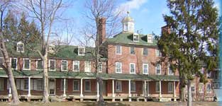
THE LAZARETTO PROPERTY CHAIN OF TITLE
Wanamaker Avenue at Second Street
Essington, Pennsylvania 19029
November 17, 1725
Will, Chester County
Israel Taylor, the elder
To
Benjamin Taylor
This Will describes the property: " . . . in the Island of Tinicum aforesaid, property called Mattinicunch Island . . . Beginning where the testator's son Christopher's land begins, and runs down the River Delaware to a fenced field which was then commonly ploughed; thence along a straight line to the swamp side then drained; thence along the swamp side to the entrance of the old road of the old landing; thence along a run side to the creek over against the widow Hendrix's, thence up the several courses of the said creek to that tree in the will before mentioned in the boundaries of Christopher's land; thence along the line of Christopher's land to the place of beginning. To hold to the said Benjamin Taylor and his heirs forever."
(Information obtained from Deed Book E, Page 160)
March 8, 1726/7
Will, Philadelphia
Benjamin Taylor
To
Thomas Taylor, his brother
The property still retains the same boundaries as previously described.
(Information obtained from Deed Book E, Page 161)
April 23, 1756
Will, Chester County
Thomas Taylor
To
Thomas Taylor, the younger
This Will mentions part of the property above: ". . . and whereby he devised a part of the said land next to the river Delaware in the same Will described and of which the tract hereinafter described . . ."
(Information obtained from Deed Book E, Page 161)
(Date unknown)
Intestate
Thomas Taylor, the younger
To
Rebecca, his wife
Israel Taylor, his son
The same property was devised as described above.
(Information obtained from Deed Book E, Page 161)
August 25, 1780
Will, Delaware County
Israel Taylor
To
Luke Smith, his brother
This will describes the following property: "...all that plantation which was leased to Joseph Penrose and also that piece of meadow ground, being in Darby Creek by the ferry being part of the land which descended to the said Israel as aforesaid and of which the tract hereinafter described and hereby intended to be granted is a part to his beloved brother Luke Smith his heirs and assigns forever, he paying his two sisters Margaret Smith and Rebecca Smith the sum of one hundred pounds, a piece or hard money when they should arrive to the age of eighteen."
(Information obtained from Deed Book E, Page 161)
(Date unknown)
Intestate
Luke Smith
To
Thomas Smith, his brother
Margaret and Rebecca, the younger, his sisters
Rebecca Smith, his mother
This deed describes the terms of conveyance according to the Intestate Laws: "And whereas the said Luke Smith survived the said Israel Taylor and by the force of the Will of the said Israel, the estate thereby devised as aforesaid vested in him the said Luke Smith. And the said Luke Smith being so there seized shortly afterwards died intestate under age and without issue leaving one brother the said Thomas Smith party hereto and two sisters the said Margaret and Rebecca, all of the same whole blood, whereupon and by reason of the said devise to the said Luke as aforesaid, and by force of the Intestate Laws then in force the premises wholly descended to the said Thomas Smith party hereto as heir at law charged with the sums payable to his two sisters according to the tenor of the said Will, and subject to the right of dower of his mother the said Rebecca Smith party hereto which she is entitled by reason of her former marriage with the said Thomas Taylor the younger."
(Information obtained from Deed Book E, Page 162)
August 7, 1799
Deed Book E, Page 162
Rebecca Smith, widow of William Smith, and widow of Thomas Taylor, the younger
Thomas Smith, grazier
To
Board of Health
This deed describes the property: "Beginning at the River of Delaware at low water mark and from thence extending along the middle of the road or land between this land and land of John Taylor, North five degrees East fifty five perches and five tenths of a perch to a post for a corner; thence by the other land of the said Thomas Smith South eighty five degrees East twenty eight perches and seven tenths of a perch to another post for a corner, thence by other land of the said Thomas Smith South five degrees West fifty six perches to low water mark of the River Delaware and from thence down the said river along the several courses and meanders thereof at low water mark to the place of beginning.
Containing and laid out for ten acres."
This deed also mentions, "And whereas the Board of Health aforesaid in execution of the said recited power to them given as aforesaid, and in order to carry into effect the purposes in the said Act of Assembly mentioned have with the consent of Thomas Mifflin, Esquire, Governor of the said Commonwealth, contracted for the purpose of the tract of land hereinafter described as a place to be called the Lazaretto, which the said Rebecca and Thomas have agreed to sell to them clear of all incumbrances, for the price or sum of Two thousand dollars lawful money of the United States of America."
The deed also describes the relationships of the grantors and other parties: "This Indenture Tripartite made the Seventh day of August in the year of our Lord one thousand seven hundred and ninety nine Between Rebecca Smith, of Tinicum Island, in the Township of Tinicum, late Ridley, in the County of Delaware, and Commonwealth of Pennsylvania, widow, and relict of William Smith, deceased, and former by the widow of Thomas Taylor, the younger, of Tinicum aforesaid deceased intestate of the first part; Thomas Smith, of the said Island of Tinicum, grazier, son of the said William and Rebecca Smith, and the brother of the whole blood and heir at law of Luke Smith late of Tinicum aforesaid, deceased, who was one of the devisees of Israel Taylor the younger, late of the same place, deceased, who was the only issue and heir at law of the said Thomas Taylor, the younger, deceased, of the second part, and the corporation by the same, stile and title of the Board of Health, created by an act of General Assembly of the said Commonwealth of Pennsylvania, entitled an Act for establishing an Health Office for securing the City and Port of Philadelphia from the introduction of pestilential and contagious diseases, of the third part."
This property was sold for 2000 dollars.
August 7, 1799
Deed Book E, Page 159
Daniel King
Margaret, wife of Daniel King, brass founder
Rebecca Smith, the younger
To
Board of Health
This property retain the same boundaries as previously described.
The property was sold for $1.00. (The sisters Margaret and Rebecca had become full age and received their 100 pounds).
January 6, 1937
Deed Book 1026, Page 109
The City of Philadelphia
To
Frank Mills
Anna L. Mills, his wife
This deed describes the property: "All the certain tract of land, located in Tinicum Township, Delaware County, Pennsylvania and known as the "Old Lazaretto" and described according to a survey made by E.M. Harris, Esquire, Beginning at a point in the bed of Second Street (60 feet wide) at the distance approximately 99 and 29/100 feet measured parallel to Second Street Westwardly from the Westerly side of LaGrange Avenue (60 feet wide); thence extending North 80 degrees 40 minutes West 476 and 72/100 feet to a pointing the bed of Second street; thence extending South 9 degrees 27 minutes West 1030 and 82/100 feet, more or less, to the low-water line of the Delaware River; thence extending in an Easterly direction along the low-water line of the Delaware River in several courses and distances thereof approximately 477 feet to the intersection of a line commencing at a point In the South side of Second Street (60 feet wide) 99 and 29/100 feet West of La Grange Avenue and extending South 9 degrees 37 minutes West and the low water line of the Delaware River; thence extending from the point of intersection of the said line and the low water line of the Delaware River North 9 degrees 37 minutes East 1043 and 8/10 feet, more or less, to the first mentioned point and place of beginning.
Containing approximately 11 and 32/100 acres."
This deed also mentions, "And whereas, by an Act of Assembly approved June 5, 1893 (P.L. 239) it was provided "The (indeciph) Lazaretto shall thereafter by abandoned and turned over to The City of Philadelphia" as by reference to the said Act will more fully and at large appear.
And whereas, by an Ordinance of the Council of the City of Philadelphia, approved September 1, 1936, entitled "An Ordinance to authorize the sale of the unused and unproductive salable real estate owned by the City," it was provided as follows:-
"Whereas, The City of Philadelphia is the owner of various p reels of real estate within its limits and elsewhere, which is unused and unproductive; and
Whereas, it is deemed advisable to sell and dispose of the said unused and unproductive real estate, or so much thereof as may be salable. . . ."
This property was sold for $10,500.00
October 9, 1945
Deed Book 1301, Page 224
Anna L. Mills Michael
Floyd Michael, her husband
To
Frank A. Mills
C. Robert Mills
J. William Mills
This deed describes, "All that certain lot or piece of ground with the buildings and improvements thereon erected lying and being on the Island of Tinicum, in the Township of Tinicum, in the County of Delaware aforesaid. Beginning at the River Delaware at low water mark and from thence extending along the middle of the road or lane between this land and land of John Taylor North 5 degrees East 55 and 5/10 perches to a post for a corner, thence by other lands of the said Thomas Smith South 85 degrees East 28 and 7/10 perches to another post for a corner, thence by other lands of the said Thomas Smith South 5 degrees West 56 perches to low water mark of the River Delaware, and from thence down the said River along the several courses and meanders thereof at low water mark to the place of beginning. Containing and laid out for 10 acres more or less.
This deed also mentions, "And the said Frank Mills dies on the Twenty-ninth day of December, A.D. 1940 and the title to the said property therefore became vested in his wife, the said Anna L. Mills, by right of survivorship. And the said Anna L. Mills has since intermarried with Floyd Michael."
The property was sold for $1.00.
August 21, 1967
Intestate, Register of Wills, Delaware County
Frank A. Mills
To
Aimee S. Mills
This deed mentions one-third interest, of the property described above, conveyed from Frank A. Mills to daughter, Aimee S. Mills.
(Information obtained from Deed Book 743, Page 303)
May 2, 1969
Deed Book 2346, page 174
Aimee S. Mills
To
C. Robert Mills
J. William Mills
This deed mentions the one-third interest, of the property described above, that was conveyed from Frank A. Mills to daughter, Aimee S. Mills, to be conveyed to C. Robert Mills and J. William Mills.
(Information obtained from Deed Book 743, Page 303)
October 7, 1986
Will No. 23-86-2186, Delaware County
J. William Mills
(John P. Trevaskis, Jr., Executor)
To
Nancy R. Mills
The property is the same as the above devised premises.
(Information obtained from Deed Book 743, Page 303)
May 22, 1989
Resignation
John P. Trevaskis, Jr., Executor of the Estate of J. William Mills
To
Murray S. Eckell
This deed mentions the resignation of John P. Trevaskis Jr. as Executor of the Estate of J. William Mills. Murry S. Eckell is appointed as Administrator, C.T.A. by the Court of Common Pleas of Delaware County, Pennsylvania, Orphan's Court Division, of the Estate of J. William Mills, Deceased.
(Information obtained from Deed Book 743, Page 303)
February 27, 1990
Deed Book 743, Page 301
Murray S. Eckell, Administrator C.T.A. of the Estate of J. William Mills
To
Nancy R. Mills Danos
The deed describes the following properties: "All those certain tracts or parcels of land, with the buildings and improvements thereon erected, Situate in the Township of Tinicum, County of Delaware, State of Pennsylvania, as shown on a plan for Robert Mills, prepared by H. Gilroy Damon Associates, Inc., Civil Engineers, Sharon Hill, Pennsylvania, dated June 17, 1969, and revised March 27, 1975, being bounded and described as follows:
Parcel A: Beginning at a point in the southerly side of Second Avenue, 60 feet wide; at the distance of 329.65 feet westwardly along the same from the westerly side of LaGrange Avenue, 60 feet wide; thence, leaving said Second Avenue, South 9 degrees 34 minutes 05 seconds West, 497.42 feet to a point; thence South 80 degrees 16 minutes East 5.02 feet to a point; thence South 13 degrees 37 minutes 30 seconds West, 87 feet to a point; thence, South 76 degrees 57 minutes 30 seconds East, 6.87 feet to a point; thence, South 13 degrees 37 minutes 30 seconds West, 59.48 feet to a point thence, South 76 degrees 22 minutes 30 seconds East, 43.33 feet to a point; thence, South 10 degrees 50 minutes 02 seconds West, 392 feet, more or less to a point in the approximate low water line of the Delaware River; thence along same, in a westwardly direction 193.50 feet more or less to a point in the line of the Riverside Yacht Club; thence along same , North 12 degrees 01 minutes 10 second East, 547 feet more or less to a concrete monument; thence still along same, North 80 degrees 16 minutes West, 11.52 feet to a monument; thence North 9 degrees 27 minutes East 485.90 feet to a point in the southerly side of Second Avenue; thence along same, South 80 degrees 16 minutes East 246.36 feet to the first mentioned point and place of beginning.
Parcel B: Beginning at a point in the southerly side of Second Avenue, 60 feet wide; at the distance of 99.29 feet westwardly along said Second Ave, from its intersection with the westerly side of LaGrange Ave, 60 feet wide; thence, leaving said Second Ave South 9 degrees 37 minutes West, 1043.80 feet more or less to a point in the approximately low water line of the Delaware River; thence westwardly along same, 193.50 feet more or less to a point; thence leaving said low water line North 10 degrees 50 minutes 02 seconds East, 392 feet more or less to a point; thence North 76 degrees 22 minutes 30 seconds West 43.33 feet to a point; thence, North 13 degrees 36 minutes 30 seconds East 59.48 feet to a point; thence North 76 degrees 57 minutes 30 seconds West 6.87 feet tot a point; thence, North 13 degrees 37 minutes 30 seconds East, 87 feet to a point; thence North 80 degrees 16 minutes West 5.02 feet to a point; thence North, 9 degrees 34 minutes 05 seconds East 497.42 feet to a point in the southerly side of said Second Avenue; thence, along same, South 80 degrees 16 minutes East, 230.36 feet to the first mentioned point and place of beginning.
Containing and laid out for ten acres more or less."
This deed also mentions, "...excepting the lot or piece of ground conveyed to Riverside Yacht Club by Deed 1079-398. . ."
July 20, 1990
Deed Book 776, Page 1674
Nancy R. Mills Danos, 50% interest
To
Nancy R. Mills Danos and
Nicholas W. Danos, her husband, 50% interest
This deed describes the same property as mentioned above.
Consideration: $1.00
February 26, 1999
Deed Book 1846, Page 0654
C. Robert Mills
Holli Anne Crane
C. Robert Mills, Jr.
To
C. Robert Mills
Holli Anne Crane
C. Robert Mills, Jr.
This deed describes the property: "Beginning at a point marked by a concrete monument set in the dividing line between property of the grantors and property of the United States to the Westward said monument being 485 and 91/100 feet measured along said line on a course South 9 degrees, 27 minutes West from a point in the Southerly side line of Second Street (60 feet wide), which point is 576 and 1/100 feet on a course North 80 degrees, 16 minutes West from the Westerly side line of LaGrange Avenue (60 feet wide): thence extending on a line parallel with Second Street South 80 degrees, 16 minutes East 111 and 52/100 feet to another concrete monument; thence extending South 12 degrees 1 minute 30 seconds West passing over another concrete monument near a stone wall, 547 feet more or less to the low water line of the Delaware River; thence extending along said low water line in a generally Westerly direction 99 feet more or less to a point formed by the intersection of the low water line and the dividing line between the property of the grantors and the property of the United States; and thence extending along said dividing line North 9 degrees, 27 minutes East, passing over another concrete monument set near the stone wall, 500 and 50/100 feet more or less to the place of beginning."
March 14, 2000
Deed Book 1992, Page 973
C. Robert Mills
Holli Anne Crane
C. Robert Mills, Jr.
To
C. Robert Mills
Holli Anne Crane
C. Robert Mills, Jr.
This deed describes the property: "All that Certain undivided one-half interest being all right titled and interest of the Grantor of in and to:
All that Certain lot or piece of ground with buildings and improvements thereon erected lying and being the Island of Tinicum, in the Township of Tinicum, in the County of Delaware, aforesaid. Beginning at the River Delaware at low water mark and from thence extending along the middle of the road or lane between this land and land of John Taylor North 5 degrees East 55 and 5/10 perches to a post for a corner, thence by other lands of the said Thomas Smith South 85 degrees East 28 and 7/10 perches to another post for a corner, thence by other lands of the said Thomas Smith South 5 degrees West 56 perches to low water mark of the River Delaware, and from thence down the said River along several courses and meanders thereof at low water mark to the place of beginning.
Containing and laid out for 10 acres more or less."
Consideration: $1.00
June 19, 2000
Deed Book 2026, Page 0721
Nancy R. Mills Danos and Nicholas W. Danos, 50% interest
C. Robert Mills, 40% interest
Holli Anne Crane, 5% interest
C. Robert Mills, Jr., 5% interest
To
Island Marine Partners
The deed describes the property: "All the certain parcel of land, situate in Tinicum Township, County of Delaware, and Commonwealth of Pennsylvania . . . Beginning at an iron pin found in the Southerly side of Second Avenue (60 feet wide) at a distance of 99.29 feet at the bearing of North 80 degrees 16 minutes West from its intersection with the Westerly side of LaGrange Avenue (60 feet wide) thence leaving said Second Avenue South 9 degrees 37 minutes West, 1043.80 feet more or less to a point in the approximate low water line of the Delaware River, thence North 78 degrees 35 minutes 14 seconds West along the same 386.96 feet; thence North 12 degrees 01 minutes 30 seconds East crossing over a found monument at the stone sea wall and continuing to another found monument 547.00 feet thence North 80 degrees, 16 minutes, West 111.52 feet to an iron pin set, thence North 9 degrees 27 minutes East 485.90 feet to a nail set on the Southerly side of Second Avenue, then along said Southerly line South 80 degrees 16 minutes East 476.72 feet to the point of beginning."
This property was sold for $2,150,000.00