
The Battle: Driving Tour of the Brandywine Battlefield
This tour details the actual battle sequence.
The number in the left column is the mileage.
BACKGROUND
While Knyphausen was creating noise and smoke along the Great Road, Cornwallis and Howe had marched north and were now positioned to attack Washington's troops unexpectedly from the north, on the east side of the Brandywine.
| 0.0 | 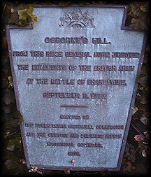 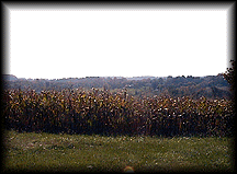 |
| 0.3 | 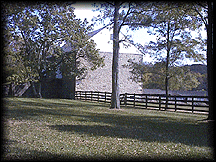 |
| 1.0 | Pause on the gravel shoulder just before the Route 926, Street Road intersection. On your right, Sullivan's men re-formed even as they were being attacked. Look beyond the modern houses to a thin line of trees. There, soldiers from Virginia, Pennsylvania, and Maryland watched the Redcoats come at them. This was the elite of the British Army in America: the Guard's Brigade, the Grenadiers, the 17th, 44th, and 64th of foot advancing to attack. If you were to turn left and drive briefly you will find a historic marker. |
| 1.2 | On your left, you can discern a cupola, which was added to the Samuel Jones Farm in the 19th Century. Now known as Linden Farm, the main building was a rallying point for the American skirmishers as they were slowly driven back from the road and orchard. Imagine the Redcoat Regulars with Hessians and dragoons sweeping down from Osborne's Hill. In 1777, the path was lined with rail fences. |
| 1.3 | 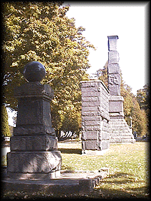 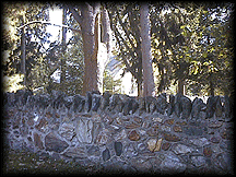 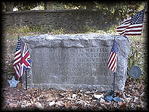 |
| 1.7 | There is a Civil War cannon on the far right corner of Wylie Road (see previous entry) which approximates the stand taken by the remnants of Sullivan's and Conway's brigades. The intensity of the fighting in this area is shown by the casulties suffered by the Redcoat 64th Foot: they lost all of their officers and 2/3 of their men either wounded or killed. It was in this area that the American cannon fire was so heavy that the description given on the front page of this website was written. At this point in the battle, Washington realized that the enemy at Chadds Ford was a secondary force and that the main battle was being fought here, three miles from his headquarters. He, therefore, led reinforcements from Greene's two brigades and had them march north to here. The soldiers covered the rough terrain, making the march in an impressive 45 minutes. Near here are what remains of Wistar's Woods. In 1777 they were so thick that when the British Grenadiers and Guards attacked through this area they were lost in the woods for over two hours and emerged in another part of the field altogether. |
| 1.9 | On your left is a slender granite column in front of a frame house. This memorial was erected in 1895 by local schoolchildren in honor of Lafayette, who helped to form the third American line near here. By late afternoon, Greene's two brigades formed in the cornfield you see when you turn left and continue along the road. |
| 2.1 | At the edge of the field you will see a cannon's muzzle pointing to the center of the field, where the road used to run. Lafayette was wounded in the left thigh as he rallied the troops here. |
| 2.3 | Constant use has worn the farm lane down until a miniature pass was formed. Known as Sandy Hollow, this gap was fiercely defended at bayonet-point by Weedon's and Muhlenberg's Virginia brigades. Heavy casualties were suffered by both sides. When the Americans learned that their left wing had withdrawn from Chadds Ford down the Chester Road (today's U.S. Route 1) and was safe, these brigades retreated in the twilight. Just ahead, on the right, is the Bennett Farm, which became a dressing station for those wounded at Sandy Hollow. This is where Lafayette was tended to. |
| 2.6 | Follow the road as it curves left. |
| 3.0 |   Across the street is the Arden Forge, an 18th Century blacksmith shop. Here they made arms for both the French and Indian War and the American Revolution. 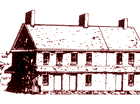 Return to your car and continue downhill (to your left, going south) on Oakland Road (Old Wilmington Pike). |
| 3.5 | You have just passed the area where the British slept for the night and stacked captured arms. Here you find the Brinton 1704 House. This architectural gem is open to the public. |
| 3.6 | Stop sign at Webb Road. |
| 3.9 | Stop sign at Harvey Road. |
| 4.3 | Take a right on Route 202. |
| 4.7 | Right onto Route 1. At the mall at this intersection, you can stop for a bite to eat. |
| 6.4 | Take a right turn back to the Brandywine Battlefield State Park. |